Home seismometers provide crucial data on Haiti’s quake
A network of inexpensive seismometers, installed in people’s living rooms, gardens and workplaces across Haiti, is helping scientists to unravel the inner workings of the magnitude-7.2 earthquake that devastated the southwestern part of the Caribbean nation this month. The community-science effort launched after the country’s last major earthquake — a magnitude-7 tremor in 2010 that killed more than 100,000 people — and has since helped to reveal details about Haiti’s seismic activity.
In a country whose official seismic-monitoring stations are sometimes offline because of limited resources, the community-seismology project provides much-needed data. Right now, the network is detecting aftershocks that continue to rattle the region. Its seismometers feed data into a system that displays the locations and magnitudes of Haitian earthquakes on a web-based portal in real time.
“It’s not professional equipment, and there are a lot of limitations,” says Dominique Boisson, a geologist at the State University of Haiti in Port-au-Prince who helps to run the network. But “some results are very nice”.
Difficult work
The network underscores just how far seismology in Haiti has come in 11 years. When the 2010 earthquake struck near Port-au-Prince, the country had no seismologists and just one official seismic-monitoring station, says Boisson. Now, there are several professional seismologists, as well as 7 stations in the official national network, which is operated by Haiti’s Bureau of Mines and Energy, and 15 in the community-science network.
Within days of the big quake hitting on 14 August, teams of scientists and technicians were driving towards its epicentre, carrying seismometers and other instruments to measure how the ground was moving. Monitoring the Earth with scientific instruments immediately after a quake allows researchers to better understand why the earthquake occurred and the future seismic risk. In 2010, it took weeks after the quake for foreign researchers to fly to Haiti and deploy instruments.
This year, many of those foreign teams are forbidden to travel to Haiti because of COVID-19 restrictions and political instability following the assassination in July of Haiti’s president, Jovenel Moïse. Instead, the work is being led by Haitian seismologists, such as Steeve Symithe, also at the State University, who, before he went into the field, was streaming Facebook Live presentations about the science of the quake to the Haitian public.
Both the 2010 and 2021 quakes happened in the Enriquillo–Plantain Garden fault zone, a tangle of fractures in Earth’s crust where the North American and Caribbean tectonic plates slide past one another. It runs from west to east along Haiti’s southern peninsula. The 2010 quake occurred on a previously unknown fault in that zone. The epicentre of the 2021 quake lies about 100 kilometres to the west, in the province of Nippes.
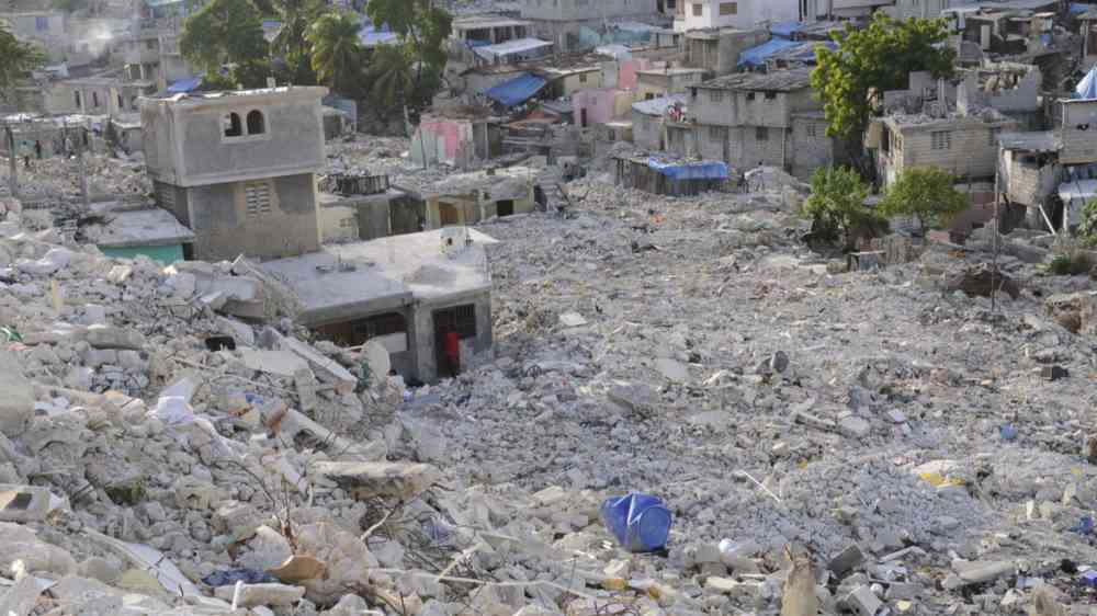
At least 2,100 people died in the 14 August quake, although the total count has yet to be tallied. The US Geological Survey estimates that there might have been more than 10,000 deaths. Many survivors endured heavy winds and rain from a tropical storm as they tried to shelter outside. The scientists en route to the area spent the night in their cars as rain pelted down, softening the ground and generating landslides as aftershocks shook the ground, Boisson tells Nature. “It was pretty difficult” for them, he says.
DIY seismology
The challenge of doing fieldwork in Haiti helped to inspire the creation of the community-seismology project in 2019. That was when Eric Calais, a seismologist at the École Normale Supérieure in Paris who has studied Haiti’s earthquakes for years, happened across a company that sells seismic stations to hobbyists. Looking for ways around the national Haitian network’s intermittent data, he used leftover money from a grant to buy some stations. Known as Raspberry Shakes, they contain tiny accelerometers that detect when the ground trembles and send that information to be processed and commingled with that from other stations.
These US$500 stations are not as sophisticated as Haiti’s official $50,000 monitoring stations. “But when it comes to locating quakes, determining magnitude, doing basic seismology — they are really excellent,” says Calais. And because they are in people’s homes and workplaces, they more often have a steady supply of power and reliable Internet access. The team, which includes Calais, Boisson, Symithe and many others, recruited people to host the stations. Boisson had one in his garden until last week, when he dismantled it to move it closer to the epicentre of the 14 August quake. The host who had the Raspberry Shake closest to the epicentre was chagrined that his station was offline during the quake; he immediately ran out and topped up his Internet plan, says Calais, and the station was soon back up and running.
Funded by international supporters, Calais and his colleagues have kept the network of 15 stations operational for two years1; they aim to soon ramp up to 50 or more stations. Community-seismology networks have sprung up in other places around the world, but the Haiti network is unique in providing data in an area where few seismic data are otherwise collected, says Calais.
The Haitian community-seismology data feed into a nationwide experimental system called Ayiti-Séismes, which is hosted at a website run by the Côte d’Azur University in Nice, France. Ayiti-Séismes also pulls data from official seismic stations in Haiti as well as those in nearby countries, including the Dominican Republic and Cuba. The result is a real-time map of aftershocks blanketing southwestern Haiti in shades of red and orange. “The network is alive and well,” says Susan Hough, a seismologist at the US Geological Survey in Pasadena, California, who has worked in Haiti for many years, including after the 2010 quake.
Future risk
The quake’s epicentre is fairly close to quakes that occurred in 1952 and 1953, which were probably between magnitude 5 and 6, says Calais. In terms of future risk, the Enriquillo–Plantain Garden fault zone could still yield another major quake. “In this area, we cannot say that it’s over,” says Boisson. Some speculate that the 2010 quake contributed to the recent one by transferring stress towards the region that just ruptured — and that seismic risk remains high in Port-au-Prince and across much of the Enriquillo–Plantain Garden fault zone.
Boisson notes that many scientists have been worried about a different major geological region in Haiti’s north, known as the Septentrional fault zone; it unleashed a major quake in 1842. “After 2010, we thought it would be this fault” that would cause future quakes, he says. “And then it was in the south again.”
About 600 aftershocks have been detected from the 14 August quake so far — compared with roughly 10 in the same time period after the 2010 quake, although there were undoubtedly more that were not detected, says Calais. “We now have very strong information about not only where the [14 August] quake occurred, but also how wide the rupture was, in which direction the fault was dipping,” he adds. “That’s essential” to understanding why the quake occurred and what to expect in the future.